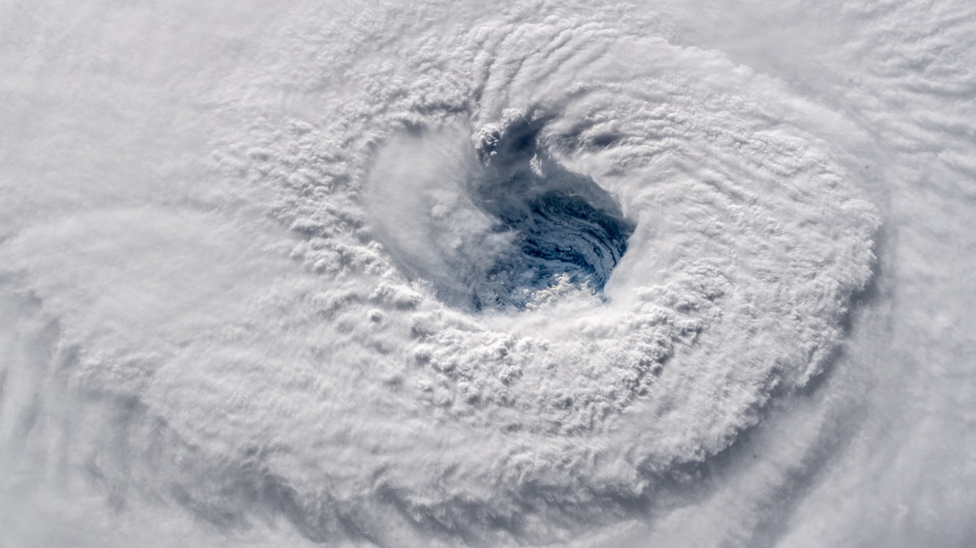
The hurricane season is expected to be more active than usual again in 2024 in the North Atlantic. A warm Atlantic Ocean and La Niña in the Pacific make the perfect combination for more storms. | Alexander Gerst/ESA/NASA
Tropical cyclone meteorologists are extremely concerned about this year's hurricane season. A series of variables and signs indicate the danger that this season will be hyperactive and one of the most intense in history, which could have catastrophic consequences in some North Atlantic countries affected by these hurricanes, such as the Caribbean and Central America. And America from the north.
Several forecasts are scheduled to be released over the next few weeks about what this year's North Atlantic hurricane season, which begins June 1, should be like. Depending on ocean conditions and what is expected for the atmosphere over the next few months, the forecast will inevitably point to an above-average to well-above-average season.
Why hurricane season this year? Because it has everything to be more active than usual, with many and several severe hurricanes reaching landfall areas. But what is this anxiety based on? There are several reasons: the return of La Niña, a very warm Atlantic Ocean, and data from climate models.
Initially, La Niña was shown to increase the probability of the North Atlantic recording more hurricanes between June and November. This is because it reduces wind shear (divergence) in the region where hurricanes form and advance. El Niño has the opposite effect, and although it was present last year, the 2023 hurricane season ended above average.
At this moment, the tropical Pacific is still experiencing El Niño, but a rapid transition to La Niña with a short phase of neutrality is expected in the coming months. The peak of the 2024 hurricane season, between August and October, will occur with La Niña already affecting the Pacific Ocean and affecting climate on a global scale, including the North Atlantic.
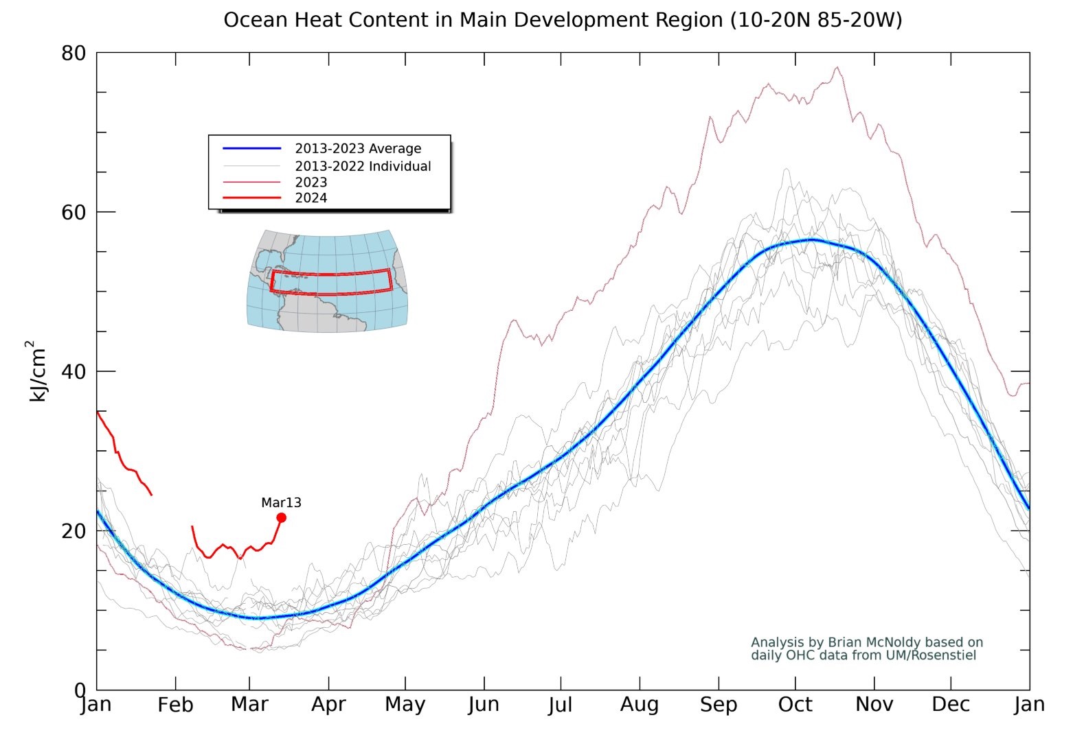
Another very important factor is the sea temperature in the Atlantic Ocean. Hurricanes form from the energy of warm water. Therefore, the warmer the sea, the greater the likelihood of an above-average hurricane season in the region. Last year, unusually warm ocean temperatures brought a season that was significantly more active than meteorologists had expected, given the presence of the El Niño phenomenon. Seven of the past few seasons have seen more storms than the historical average.
Meteorologists are monitoring part of the Atlantic Ocean in particular. It is called abbreviated: MDR. This is called major regional development. The temperature in this part of the Atlantic Ocean, called the MDR, is currently much higher than normal.
Why does this matter? The Major Development Region (MDR) is the part of the North Atlantic Ocean bounded between 10°N-20°N and 20°W-60°W where about 79% of all intense hurricanes form from easterly waves advancing from Africa. The amount of tropical cyclone activity that forms in the MDR strongly influences the overall activity of the hurricane season.

Brian McNoldy/University of Miami
If the MDR is very hot, as it is now, and the waters remain at current levels or warmer in the coming months, ideal conditions will be in place for a very active hurricane season. The combination of two very favorable signs for hurricanes, La Niña in the Pacific and a warming of the Atlantic, is the perfect combination for a hurricane season that is more active than usual with disastrous consequences.
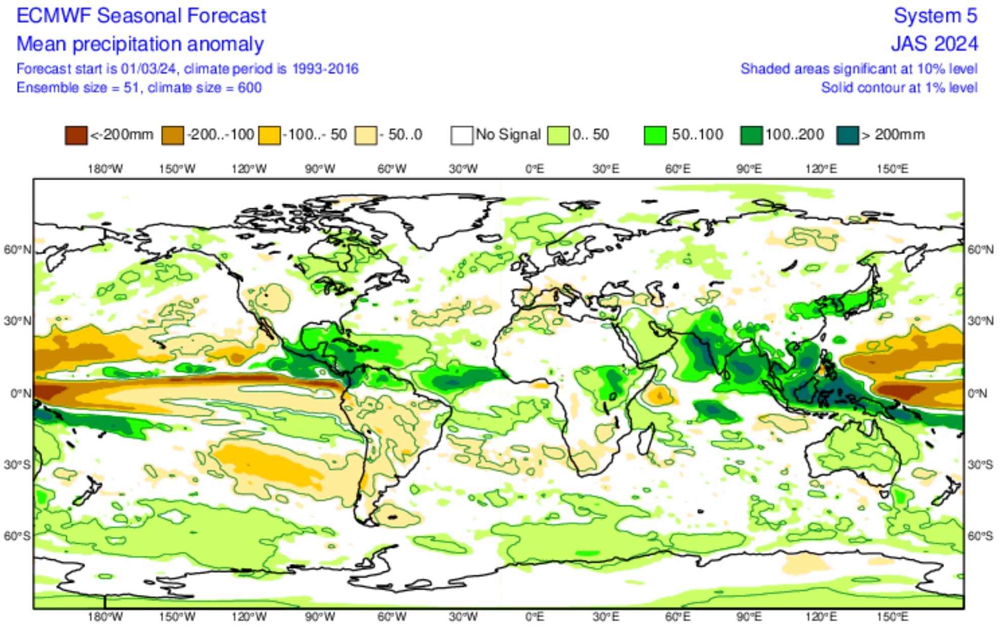
This is beginning to be demonstrated in climate models with long-term projections. Data indicate above-average to well above-average precipitation during the season in areas where hurricanes form and advance, from coastal Africa to the Caribbean, Central America and the southeastern United States.

ECMWF
Signaling above-average rainfall is, in the opinion of many meteorologists, an indication of more tropical cyclones (tropical storms and hurricanes), phenomena that, in addition to damaging winds, also cause unusual amounts of rain wherever they pass. .
However, meteorologists believe that it is too early to say that this season will be disastrous. Likewise, it is not yet clear why the Atlantic Ocean is warming more than other oceans, or how long this warming will last.
MetSul Meteorologia is available on WhatsApp channels. subscription here To access the channel in the messaging application and receive forecasts, alerts and information about the most important weather and climate events in Brazil and around the world, with exclusive data and information from our team of meteorologists.

“Hardcore beer fanatic. Falls down a lot. Professional coffee fan. Music ninja.”


More Stories
The law allows children and adolescents to visit parents in the hospital.
Scientists pave the way for the emergence of a new element in the periodic table | World and Science
Can dengue cause hair loss? Expert explains how the disease affects hair