A special report by Vega magazine listed the 10 most amazing scientific discoveries, nationally and internationally, for the year 2023. Among them is the discovery of 24 archaeological sites in the Amazon region, some of which are in the state of Akko.
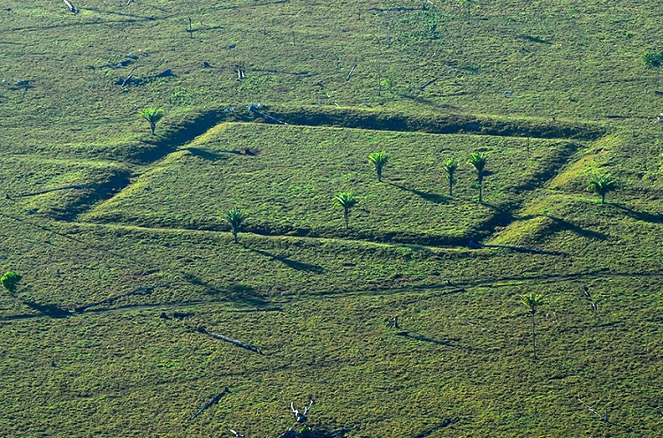
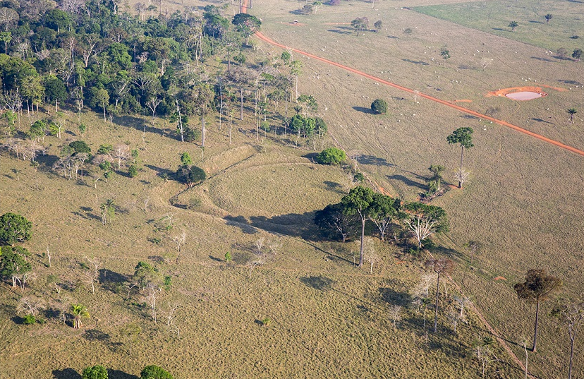
In deforested areas of the western part of the Amazon, it is possible to observe giant geometric shapes on the ground, called geoglyphs, which from the 2000s onwards began to be seen through satellite images, both by scientists and amateurs, using Google Earth. .

One of the geoglyphic inscriptions found in Akko. Fazenda Parana/Photo: IPHAN
In addition to the 24 archaeological sites discovered in Acre, Mato Grosso, Amazonas, Pará and Amapá, while investigating less than 1% of the territory of the Amazon, the study by researchers from the National Institute for Space Research (INPE) estimates that there may still be as many as 23 A thousand pre-Columbian buildings are scattered throughout the area.
The Amazon Basin has been home to various indigenous communities for more than 12 thousand years. These people created structures and occupied areas of the jungle, leaving marks on the current configuration of the Amazon.

Rio Branco has 47 geographies/Photo: Disclosure/Iphan
Even with all the studies and investigations on this topic, the extent of the impacts these societies have had is little understood. Most of the sites are located in remote locations and hidden under dense forests.
Geography of Akko
Throughout Akko, more than 300 archaeological sites of geoglyphic type have been identified, consisting of 410 geomorphic structures, a total that is increasing due to the development of archaeological research in the state.

Geoglyphs are made up of different geometric shapes/Photo: Diego Gurgul/SECOM
According to the Secretariat of Economic Development, Tourism, Technology and Innovation (SDTI), they revealed that in Rio Branco alone, there are 47 archaeological sites of geoglyphic type, with huge tourism and economic potential for the region.
The municipality of Rio Branco has mapped the three main tourist routes leading to some of the state's best-known geoglyphs. paying off:
BR-364 – Rio Branco/Porto Velho
There are some well-studied and dated geoglyphs on this road. The proximity to the capital invites residents to explore this heritage and return home on the same day. During the visit, tourists can try to create hypotheses about the origin and age of the structures.
atlantic farm: It is located 24 km after leaving Rio Branco, towards Porto Velho, 500 meters from the right bank of the highway. It consists of two buildings, one of which is square with a side length of about 250 metres, and the other is circular with a diameter of 125 metres. According to research, it is estimated that the buildings were built at the beginning of the Christian era, and were occupied until the third century.
Alto Alegre location: Located two kilometers from the Atlantica farm and still on the right bank, which this time is crossed by the highway, is the circular Alto Alegre, 150 meters in diameter. It contains double trenches up to 3 meters deep. According to research, it was built about 200 years before the beginning of the Christian era, and was occupied until the end of the second century.
November 5th: Next, in the same direction, is the Cinco de Novembro Geoglyph, composed of a rectangle measuring 117 meters by 144 meters 36 km east of the site of Alto Alegre, still on the right bank of the highway.
Dinar website: Located 9 kilometers from Cinco de Novembero, this time on the left bank, JD Geoglyph has two square buildings, each 130 meters long. The trenches at this site are 12 and 14 meters wide and 1.6 and 2.1 meters deep.
Arif farm website: It is located 19 km from Geoglifo JD, on the right bank of the BR364, just before the entrance to Acrelândia. It is a trapezoid, its side length ranges between 90 and 70 meters, and its depth reaches 1.5 metres.
BR 317 – Rio Branco / Boca do Acre
Fazenda Baixa Verde II: Leaving Rio Branco towards Boca do Acre, after 28 km, on the right bank of the highway. It consists of a square structure interrupted by a highway. The square has a side length of 120 metres, and the trenches are approximately 14.7 meters wide and 1.5 meters deep.
Severino Calazan: At 4.5 km from Baixa Verde II Geoglyph, towards Boca do Acre, located on the left, is the Severino Calazans Geoglyph, which is also crossed by the motorway. It is a square with a side length of 230 metres, and a trench 12 meters wide. This is one of the oldest sites because, according to studies, it was built a thousand years before the Christian era.
Jaco Sa: One of the most famous and globally recognized. There are visiting hours and it is possible to walk on it quietly. To get there, just walk straight, 8 km north of the site of Severino Calazan, also on the left bank. It consists of two square structures, one of which contains an inscribed circle. Studies conducted reveal that its construction and use took place in the second half of the first millennium, between the sixth and eighth centuries.
Tequinho website: Another world-famous geographical feature is Tequinho, located 11 km away. Near the entrance to Villa Pia, on the right, on the Ramal du Pelé for 2.5 km, you reach the site of the archaeological site. Many consider the Tequinho site to be the most complex. There are two large squares, with triple ditches and a wide path towards the river.
BR 317 – Rio Branco/Zaporí
Geoglyph PR 317: After a distance of 66.5 km towards Zapori, the highway passes through the site of the same name. It consists of two irregular structures: an oval measuring 100 meters by 85 metres, and a second ditch around it that starts more clearly next to the highway.
Bimpara: After 28.5 km, you will find Bembara Geography, located on a farm just 1 km from the center of Capixaba. These are two structures connected by the same moat. The largest structure is an irregular circle with a diameter of 260 meters. The written shape is a rectangle. The trenches are about 12 meters wide.
Bontao Farm: After 17 km you reach Fazenda Puntao, where there is a 145 meter square geograph with rounded corners. The trench is 11 meters wide and 1.5 meters deep.
Altrunorti 1 website: After 19 km, on the right bank of the highway, you reach Sitio Eletronorte I, which has an octagonal shape and is 328 meters in diameter. Measuring 13 meters wide and just over 1 meter deep, the trench is 17 meters wide and 3 meters deep, and its small size provides a good view of the entire structure.
Los Angeles location: It is located within a farm, 1.5 km from the motorway and with an entrance 11 km from Sítio Piçarreira, on the left bank of the BR-317. With a deep ditch with a diameter of 200 metres, it is located at the top of a valley crossed by the Abuna River. The site was probably built 200 years before the Christian era, and remained inhabited until at least the 5th century.

“Hardcore beer fanatic. Falls down a lot. Professional coffee fan. Music ninja.”


More Stories
The law allows children and adolescents to visit parents in the hospital.
Scientists pave the way for the emergence of a new element in the periodic table | World and Science
Can dengue cause hair loss? Expert explains how the disease affects hair