

![[VÍDEO] Elton John’s final show in the UK has the crowd moving](https://www.lodivalleynews.com/wp-content/uploads/2023/06/Elton-John-1-690x600.jpg)

Known for its vast and arid landscape, the Sahara Desert rarely experiences significant rainfall. However, when it does finally fall, it can dramatically change the landscape. Recently, an unusual weather event brought heavy rain to the region, highlighting the importance and rarity of such phenomena. This article explores the impact of these rains, their causes, and their implications for understanding weather patterns in the Sahara Desert.
The Sahara is the world’s largest non-polar desert, covering about 9.2 million square kilometers in North Africa. The desert is characterized by sand dunes, plains, and rocky mountains, and its climate is predominantly arid, with daytime temperatures exceeding 50 degrees Celsius, and annual rainfall in some areas does not exceed a few millimeters. Vegetation is scarce and life is adapted to the harsh conditions of drought and heat.
Rainfall in the desert is typically sporadic and limited. Most precipitation falls during the summer, but even then, it is short and localized. Water scarcity is a defining characteristic of the desert, and the infrastructure for measuring and monitoring rainfall is limited due to the vastness and inhospitability of the area. Therefore, when large amounts of rain do fall, they are notable events that attract the attention of scientists and meteorologists.
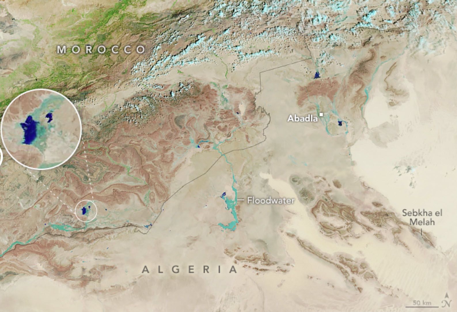
In September 2024, an extratropical cyclone formed over the Atlantic Ocean and moved toward North Africa, bringing with it an unusual amount of moisture. This rare weather system brought heavy rainfall that affected large areas of the northwestern Sahara, including parts of Morocco, Algeria, Tunisia, and Libya. The accumulated rainfall in some locations was equivalent to what would normally be expected in an entire year, an unusual event for this region.
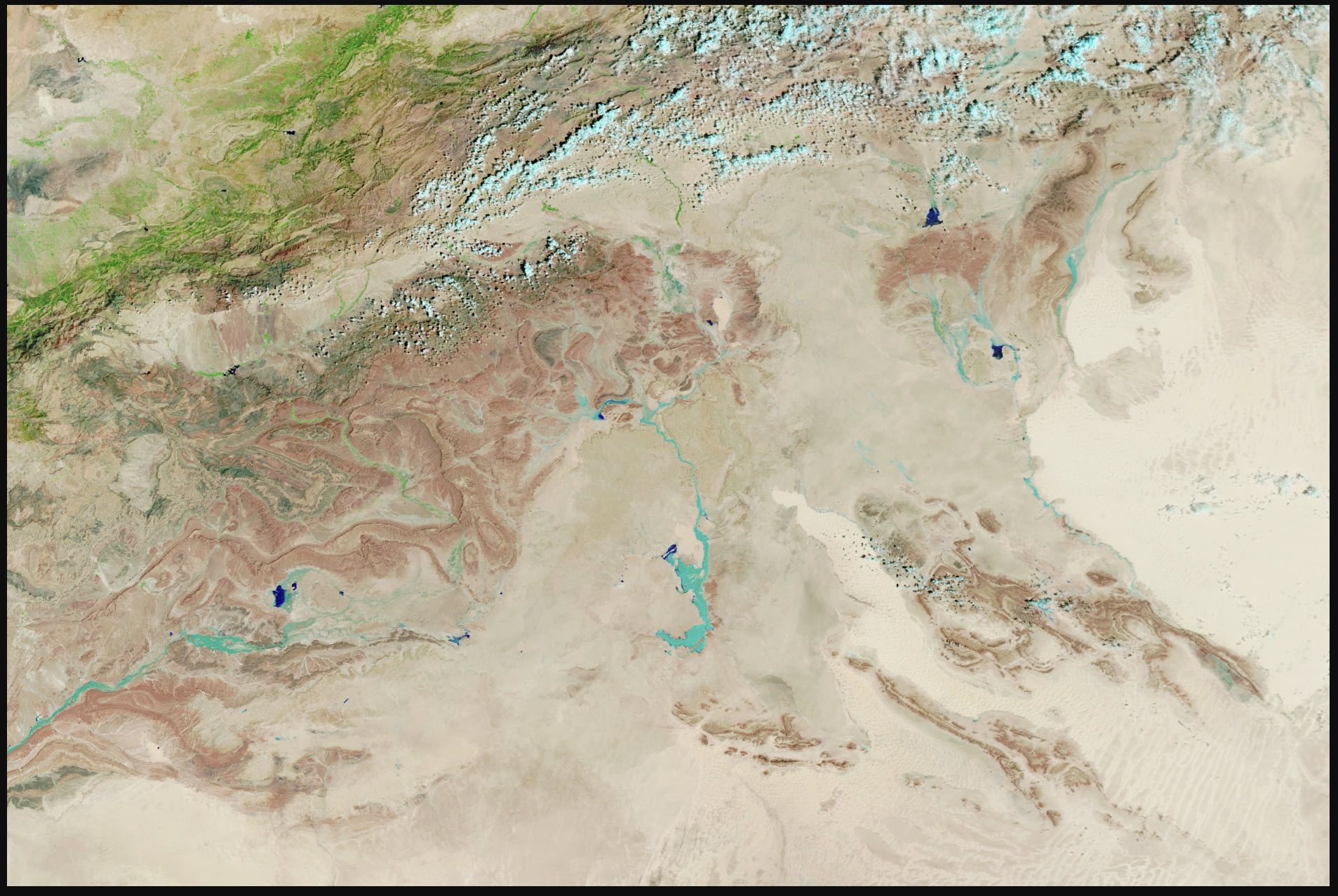
The event was captured by NASA satellites, which provided detailed images of the affected areas. Using MODIS (Moderate Resolution Imaging Spectroradiometer) on the Terra satellite, scientists were able to observe the impact of the rain on the landscape of the Sahara Desert. The false-color images revealed the extent of flooding and the formation of temporary lakes in areas that are normally dry. These observations are crucial to understanding the dynamics of desert rainfall events and their consequences for the environment and local communities.
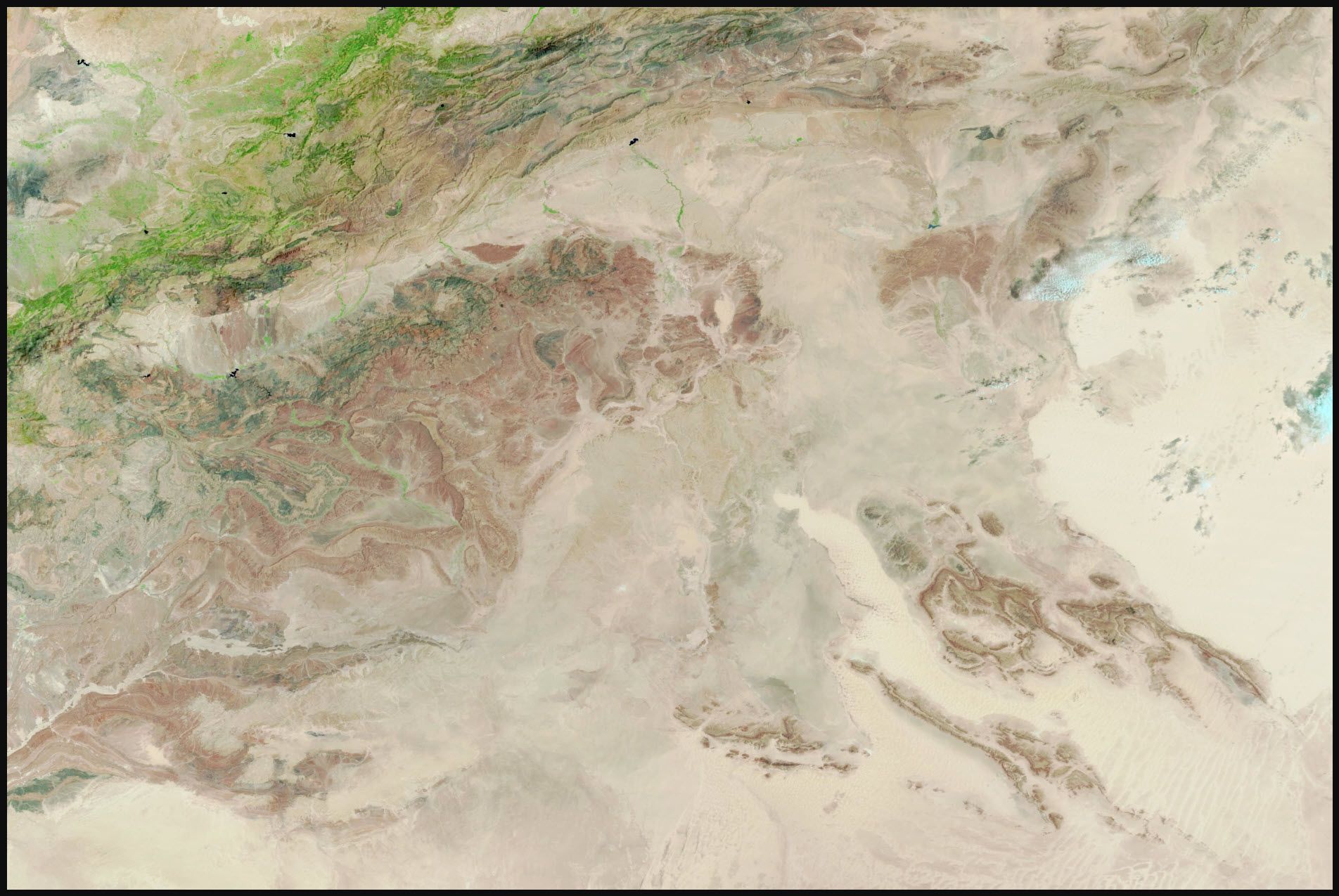
On September 7 and 8, 2024, an unusual extratropical cyclone crossed the northwestern Sahara Desert, bringing heavy rains to parts of Morocco, Algeria, Tunisia, and Libya. This rare weather event produced rainfall ranging from tens to more than 200 millimeters, an amount equivalent to the average annual rainfall for these areas. The storm formed over the Atlantic Ocean and extended southward, pulling moisture from tropical Africa to the northern Sahara Desert, a rare occurrence.
While much of the rain fell in sparsely populated areas, several villages in Morocco faced devastating flooding, road damage, and power and water outages. Satellite imagery captured by MODIS (Moderate Resolution Imaging Spectroradiometer) on NASA’s Terra satellite revealed widespread flooding and runoff, with areas covered in water appearing in shades of dark blue and light blue. The depth of the water and the amount of suspended sediment affect these tones.
In addition to the direct impacts on human communities, the event also caused major changes to the landscape. Normally dry lakes in the Sahara began to fill, as seen in areas such as Iriki National Park in Morocco and Sebkha el Melh, a salt plain in central Algeria. The phenomenon of dry lake filling is extremely rare, and has only been recorded six times in the past two decades, according to recent studies.
Dr. Moshe Armon, a senior researcher at the Institute of Earth Sciences and the Hebrew University of Jerusalem, noted that this event was unique because of the involvement of an extratropical cyclone. Using data from NASA’s IMERG (Integrated Multi-satellite Retrievals for GPM), Armon and his team were able to systematically assess rainfall over large areas of the Sahara Desert, where ground-based measuring stations are scarce. Initial analysis indicated that this event was one of the few extratropical cyclone-related events during the summer, a season that typically sees less intense rainfall events.
The researchers analyzed two decades of IMERG data to better understand the frequency of heavy rainfall events in the region. They identified more than 38,000 heavy rainfall events in the Sahara, about 30% of which occurred during the summer. However, only a small fraction of these summer events were associated with extratropical cyclones, highlighting the exceptionality of the September 2024 event.
Studying such extreme weather events is crucial to deepening our understanding of climate change and global weather patterns. The occurrence of an extratropical cyclone in the Sahara and its consequences highlights the need for continuous and detailed monitoring of climate conditions in arid regions. Moreover, these events provide valuable data for climate modeling and forecasting of future extreme events, contributing to preparedness and mitigation of their impacts. Continued research in this area can reveal new information about atmospheric dynamics and the response of ecosystems to extreme weather events, providing important insights for climate science and environmental management.
source:
More Stories
What ChatGPT knows about you is scary
The return of NFT? Champions Tactics is released by Ubisoft
What does Meta want from the “blue circle AI” in WhatsApp chats?