July 2024 was very dry and hot across central Brazil.This is due to the strong atmospheric blocking pattern that has imposed itself on the region. Water rationing has become a reality in many municipalities in the interior, and the high temperatures help to maintain the cost of electricity (in the yellow tariff science), due to the high demand.
The weather forecast for August has little encouraging news: The southeast and central-west will remain very hot and have below average rainfall until at least early September..
High temperatures throughout the month
As in July, it will be common for thermometers to show temperatures Above 35°C In August in most of the Midwest and much of the Southeast.
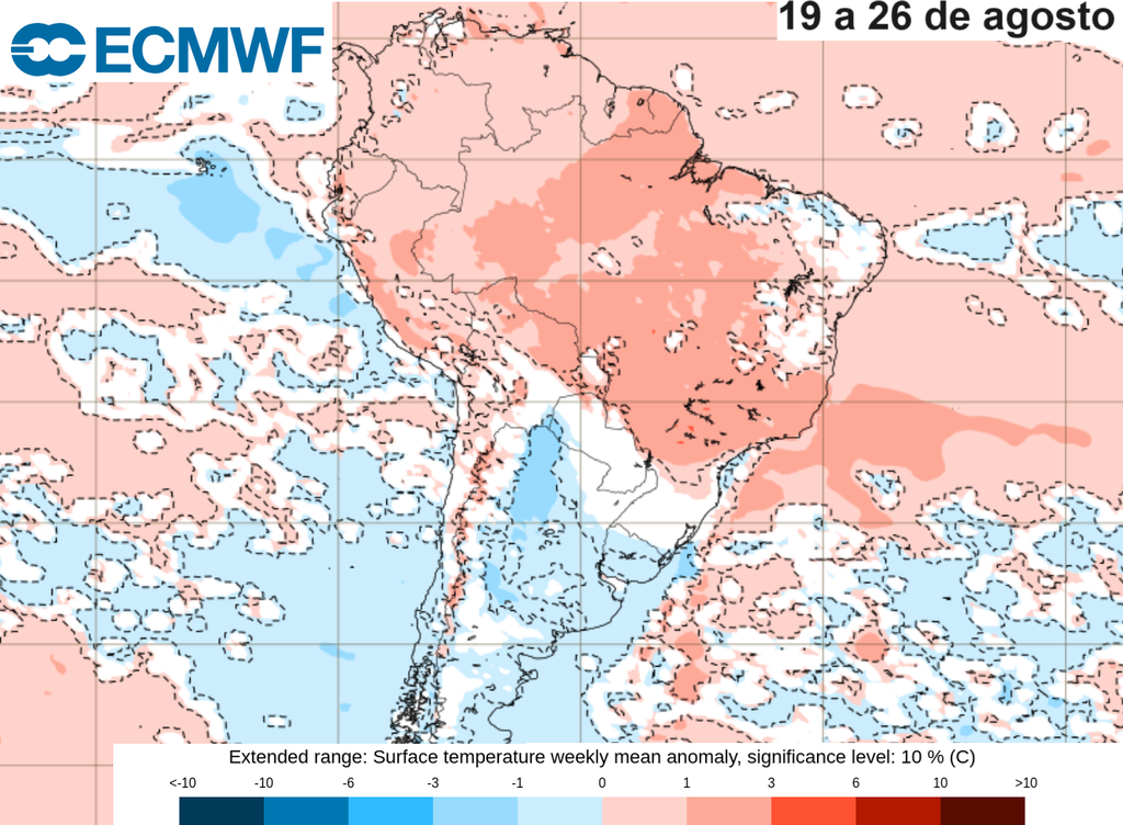
The action of slightly cooler air masses will keep temperatures down. Close to average in the southern region almost all monthIt will also help keep temperatures on the Sao Paulo coast more moderate.
Extreme heat in central Brazil It also extends to the northern and northeastern regions..
Mainly dry weather in the second two weeks.
As for rain, the first two weeks of August will bring some relief to some areas.The month begins with dry weather in the interior, with the most significant rainfall expected to be concentrated on the coasts of Brazil, from Santa Catarina to Bahia. In the week of August 5-12, models predict slightly above average rainfall in southern São Paulo and Mato Grosso do Sul, within average in other areas of the center-west, and below average in northern Minas Gerais, Espírito Santo and Bahia.
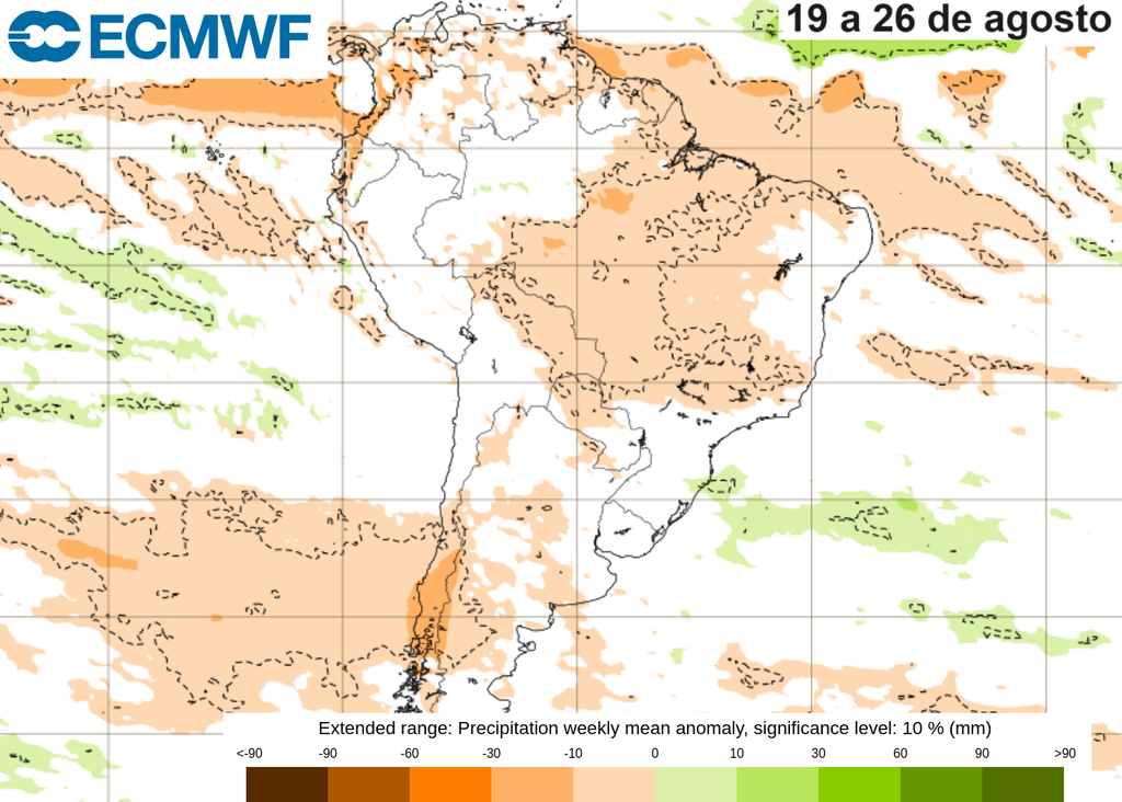
Rainfall in central Brazil is expected to be close to what is usually recorded (it is worth remembering that there are no significant accumulations for August) also in the week between the 12th and the 19th. However, after the 19th day, the drier pattern re-establishes itself.and below average accumulations are expected to continue through early September!
With dry and hot weather dominating, we are expected to once again have a month where humidity levels drop to levels that can be harmful to human health. It is important to always remember to stay hydrated and avoid outdoor physical exercise during the hottest hours of the day..
Weather pattern is influenced by the stratosphere.
The climatic conditions of a given period are the result of many different phenomena acting together in the atmosphere. The scenario that emerges during August is consistent with expectations of a negative phase of the Southern Annular Mode, or Antarctic Oscillation (AAO)..
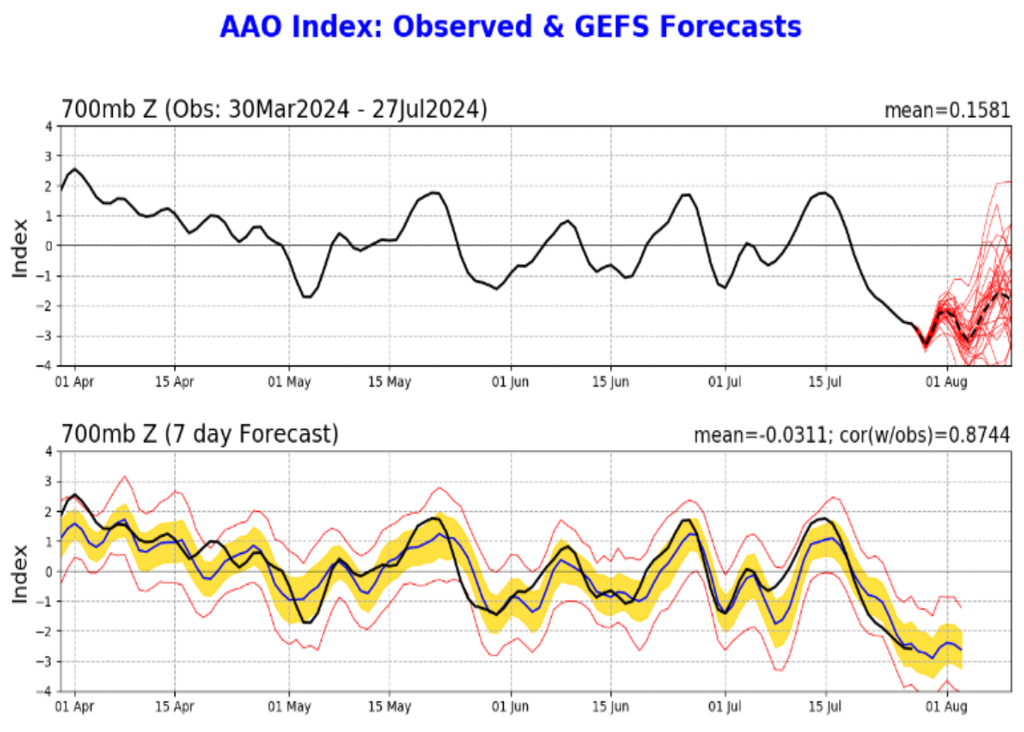
The AAO is a climatic phenomenon related to the periodic change in winds around Antarctica, and affects the entire Southern Hemisphere. When the AAO is in a negative phase, the winds tend to decrease, causing an effect in areas far from the pole – such as Brazil, for example.Studies indicate that this phase is associated with a decrease in rainfall and an increase in temperatures in central Brazil, which is exactly what we will observe in August..
One interesting aspect of the AAO is that this visible effect on the surface is the result of a phenomenon that begins much higher up, at about 30 kilometers, in the layer of the atmosphere we call the Stratosphere (Where the famous “ozone layer” is located). It is now known that when this upper part of the atmosphere rises, its temperature rises. (There are phenomena that lead to its rise to 50 degrees Celsius!) It tends to “force” the AAO into its negative phase.Then the negative phase moves towards the surface, until after a few days its effects begin to appear in the layer close to the ground in which we live.
This can be seen in the figure below, which shows the time evolution of the stratospheric temperature anomaly, along with the evolution of the AAO phase signal.
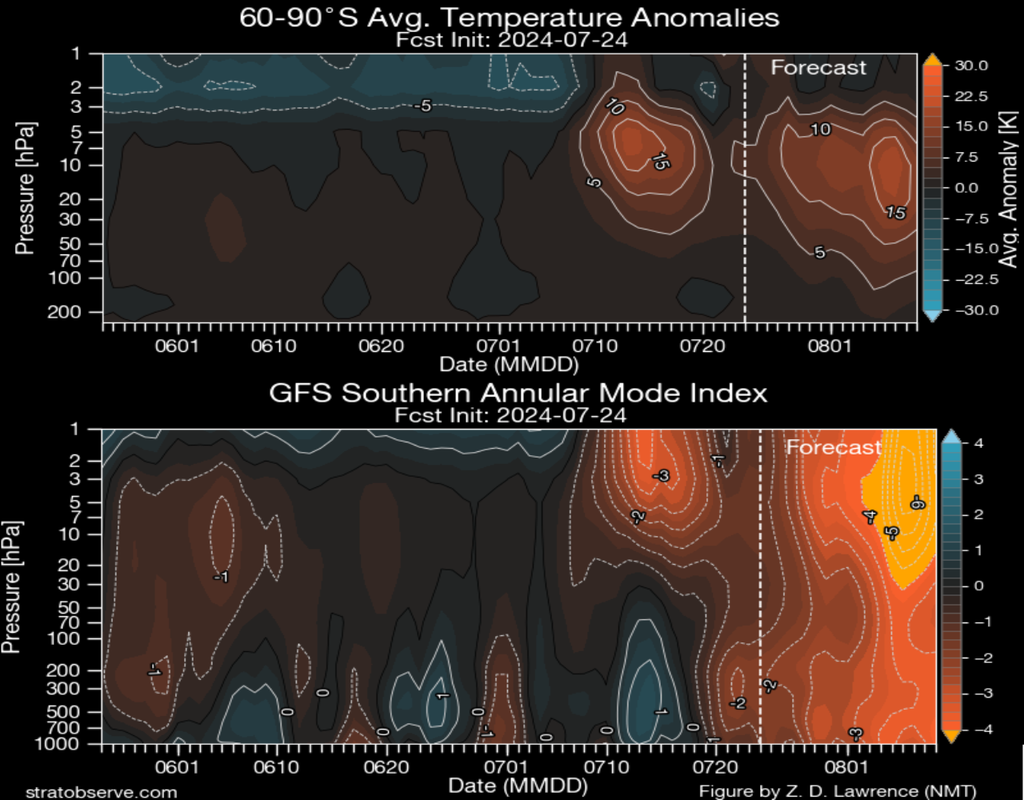
The figure above shows that the stratospheric warming around July 15 led to a change in the AAO signal at the surface from July 20. The steady negative signal remained until the 24th, and is expected to intensify. The figure also shows aA new rise in stratospheric temperature, stronger than in July, is expected in early August.This would cause the AAO to remain negative for a few weeks – and therefore, Leads to expected rainfall patterns and temperatures in central Brazil.
What can we expect after August?
You ECMWF Climate Prediction Models It indicates that high temperatures will continue over the next few months, but rainfall patterns are expected to change slightly in central Brazil. From September onwards, and especially from October onwards, we will be able to record accumulations close to average, or even above average. This change is in line with the emergence of the La Niña phenomenon, which is expected to occur over the next few months – and although weak, it could bring this welcome change.
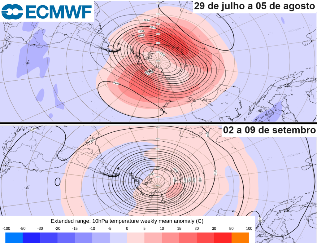
Models also indicate a sharp decrease in stratospheric warming throughout August (as shown in the figure above). Given the relationship between upper-level temperature and the AAO, this could mean that the negative phase of the oscillation will not be as strong from September onwards. Therefore, it will help us enjoy an early spring with long-awaited rainfall in the central region of Brazil, close to or above average..

“Music fanatic. Professional problem solver. Reader. Award-winning tv ninja.”





More Stories
Couple retakes glacier photo after 15 years, surprised by changes: ‘It made me cry’
Two killed in hotel collapse in Germany – DW – 07/08/2024
Lula speaks for half an hour on phone with Biden about Venezuela’s electoral impasse | Politics