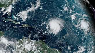
The North Atlantic could face up to seven major Category 3 or higher hurricanes this year, more than double the usual number, the U.S. National Weather Service has warned.
Typically, three major hurricanes are expected in one season.
Up to 13 Category 1 or higher hurricanes are expected to occur in the Atlantic Ocean from June to November.
Record sea surface temperatures and a potential shift in regional weather patterns are partly to blame.
While there is no evidence that climate change is increasing the number of hurricanes, it does make more powerful events more likely and bring more heavy rainfall.
“This hurricane season promises to be exceptional,” National Oceanic and Atmospheric Administration (NOAA) Administrator Rick Spinrad said at a news conference.
The recent weakening of the El Niño weather pattern — and a potential transition to La Niña conditions later in the year — creates more favorable weather conditions for these Atlantic storms.
In contrast, the National Oceanic and Atmospheric Administration (NOAA) previously predicted a “below normal” hurricane season in the Central Pacific, where the transition to La Niña would have the opposite effect.
On average, the Atlantic Basin – which includes the Atlantic Ocean, Caribbean Sea and Gulf of Mexico – records 14 named tropical storms annually, seven of which become hurricanes and three become major hurricanes.
Tropical storms turn into hurricanes when sustained winds reach 74 mph (119 km/h). Major hurricanes (Category 3 and above) are those that reach at least 111 mph (178 km/h).
The National Oceanic and Atmospheric Administration (NOAA) forecasts a total of 17 to 25 named tropical storms, of which between eight and 13 could become hurricanes and between four and seven could become major hurricanes.
The most major hurricanes in a single season in the Atlantic are seven, recorded in 2005 and 2020. National Oceanic and Atmospheric Administration (NOAA) forecasts indicate that 2024 could approach that record.
The exact causes of individual storms are complex, but there are two main factors behind these predictions. First, there is the potential shift from El Niño to La Niña in the coming months, which will facilitate the growth of these storms. Second, sea surface temperatures are warmer than normal in the main tropical hurricane zone in the Atlantic Ocean.
This generally means more powerful hurricanes, as warmer waters provide more energy for storm growth as they move west. “All the ingredients are in place” for a severe hurricane season, said Ken Graham, director of the US National Weather Service.
To shed light on how global warming is increasing the likelihood of extremely intense storms, a recent study explored the possibility of creating a new sixth category.
This “would alert the public that the strongest tropical cyclones we are seeing are unprecedented, and the reason for this is because of the warming of the oceans due to climate change,” explains Michael Weiner, lead author of the study and chief scientist at Berkeley Earth.
Hurricane categories take into account wind speed only. However, the National Oceanic and Atmospheric Administration (NOAA) has warned that these storms present other significant risks, such as heavy rainfall and coastal flooding, which are generally worsening with climate change.
Warmer air can hold more moisture, increasing the intensity of precipitation.
In addition, storm surges—the temporary rise in sea level caused by hurricanes—now occur over a higher base. This is due to sea levels rising, mainly due to melting glaciers and rising ocean temperatures.
“Sea level rise increases the total depth of flooding, making today’s hurricanes more damaging than those of previous years,” says Andrew Dessler, a professor of atmospheric sciences at Texas A&M University.
Given the active forecast, researchers stress the public should be aware of the risks these storms can pose — especially “rapid intensification events,” where hurricane-force winds increase very quickly and can be particularly dangerous.
“We are already seeing overall increases in faster rates of hurricane intensification in the Atlantic Ocean – which means we are likely already seeing an increase in the risk of hazards to our coastal communities,” explains Andra Garner, an assistant professor at Rowan University in the US.
“Rapid intensification of storms remains difficult to predict, which in turn increases challenges in protecting our coastal communities.”
Graphics by Erwan Rivoult and Mosquin Lidar


![[VÍDEO] Elton John’s final show in the UK has the crowd moving](https://www.lodivalleynews.com/wp-content/uploads/2023/06/Elton-John-1-690x600.jpg)


More Stories
The Director of Ibict receives the Coordinator of CESU-PI – Brazilian Institute for Information in Science and Technology
A doctor who spreads fake news about breast cancer is registered with the CRM of Minas
The program offers scholarships to women in the field of science and technology